The road & its landscape
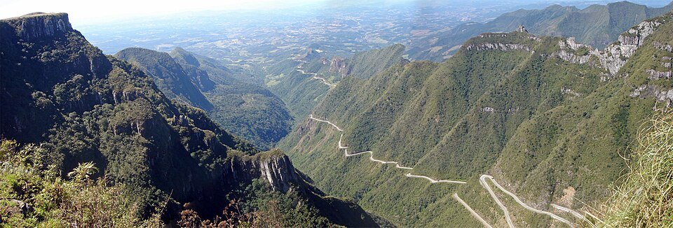
SC-390 climbs the steep Serra Geral escarpment through tightly folded bends. Forested walls below and the highland rim above create a particularly clear change from low valley to plateau.
Use SC-390 for the mountain climb. Serra do Corvo Branco is another road and is not substituted for this route.
Scenery along the road
The lower approach is enclosed by humid green slopes. In the climbing section, successive road levels appear against the escarpment. At the upper rim, a signed lookout lets you read the bends as a whole after parking.
Lauro Müller foothills
The road approaches a steep forested wall, with the upper highland still out of view.
Escarpment switchbacks
Short climbing bends stack against the slope; sightlines, damp pavement and opposing vehicles need attention.
Bom Jardim rim
The landscape opens above the escarpment; the overhead road view is from a separate lookout stop.
Roads from above
Look at the bends, road surface and landscape beside the carriageway. Each caption identifies the location; other roads in the range are marked separately.
Paulo Hopper · CC BY-SA 4.0 · Thumbnail / display crop · Licence
Claudete Rejane Batista Estulla · CC BY-SA 4.0 · Thumbnail / display crop · Licence
Sarah Marcelino (Projetos Wiki) · CC BY-SA 4.0 · Thumbnail / display crop · Licence
Road conditions & preparation
Check Santa Catarina road-police and municipal updates before travel. Fog, rockfall, ice and temporary traffic controls can alter the crossing. A July 2026 normal-traffic notice is background evidence, not a live access guarantee.
Mountain landscapes
Photographs identify their actual location, author and licence. Viewpoints away from the riding corridor are stated in the captions; photographs are not verified ride records.
Mariordo Mario Roberto Duran Ortiz · CC BY-SA 3.0 · Thumbnail / display crop · Licence
Victor J. Zomer · CC BY-SA 4.0 · Thumbnail / display crop · Licence
Otávio Nogueira from Fortaleza, BR · CC BY 2.0 · Thumbnail / display crop · Licence
Sources & provenance
- Bom Jardim da Serra municipality: SC-390 traffic update ↗
- Santa Catarina infrastructure department: SC-390 road schedule ↗
Summarised from public sources. A historic tourism plan describes a corridor, not current road access. Track authors retain ownership of their files.