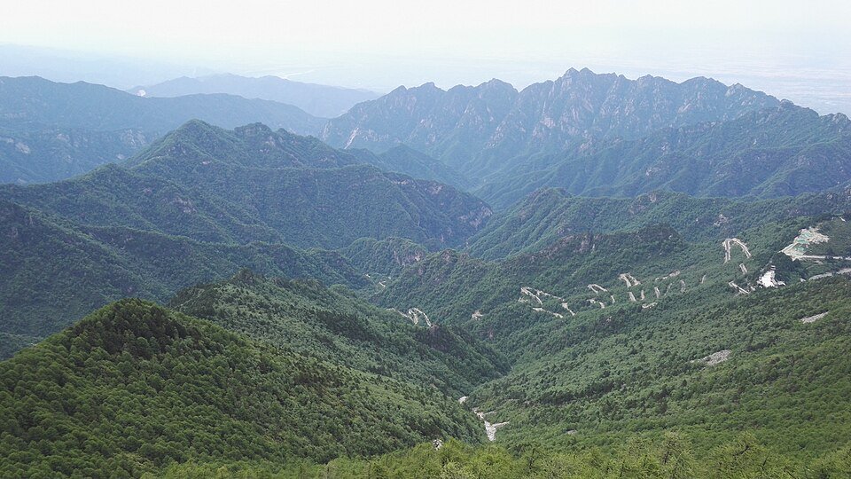
The road & its landscape
G210 through Ningshan is a sequence of wooded climbs and village valleys. Guanghuojie gives way to the mountain country around Jiangkou, Yueheliang and Pingheliang, where the road itself is the foreground to dense Qinling vegetation. The scenery rewards attention to changing enclosure, forest texture and settlements along the old north–south corridor.
Road corridor: Guanghuojie → Jiangkou → Yueheliang → Pingheliang → Ningshan · G210 corridor.
Why ride here
G210 through Ningshan is a sequence of wooded climbs and village valleys.
Scenery along the road
The local road description identifies Yueheliang as a scenery section and Pingheliang as a forest-viewing section. That gives this chapter concrete road settings, rather than generic mountain praise. Start with Guanghuojie’s settlement and canyon surroundings, then follow the succession of valley towns and wooded ridges. Autumn offers a different palette from summer, especially around Pingheliang: foliage makes the forest texture more varied while the ridge-and-valley sequence remains recognisable.
Guanghuojie canyon-side settlement
Guanghuojie is a roadside settlement associated with G210’s long history as a route between Xi’an and the south. Its setting brings buildings and daily life into the mountain scene. The nearby Qinling canyon attraction is a separate visit, while the road chapter focuses on the transition from town into wooded slopes.
Jiangkou to Yueheliang
Between the Jiangkou chapter and Yueheliang, the interest shifts from a valley settlement to the wooded ridge landscape. Local transport material calls out Yueheliang’s natural scenery. View the road as a line within the vegetation, with close forest giving way to mountain layers where the terrain opens.
Pingheliang forest road
Pingheliang is specifically identified in local road material as a forest sightseeing section, and forestry sources include it in an autumn-colour route. This is a slower visual chapter of tree trunks, foliage and mountain slopes. The same wooded slopes read differently as leaves change, with closer foliage making a richer foreground beneath the layered mountain forms.
Road conditions & preparation
Choose the exact public-road connections first, then check road works, local motorcycle access and scenic-area transport. Plan stops at confirmed parking areas and add fuel and lodging information to the roadbook. Confirm whether your selected G210 itinerary uses ridge sections or tunnel diversions; historical road photographs may show the older line.
Mountain landscapes
Photographs identify their actual location, author and licence. Viewpoints away from the riding corridor are stated in the captions; photographs are not verified ride records.
Wenmingxing · CC BY-SA 4.0 · Thumbnail / display crop · Licence
Wenmingxing · CC BY-SA 4.0 · Thumbnail / display crop · Licence
Shedous · CC BY-SA 4.0 · Thumbnail / display crop · Licence
Sources & provenance
- G210 Qinling tourism belt: ridge and valley nodes ↗
- Ningshan scenic trunk roads: Yueheliang and Pingheliang ↗
- Guanghuojie and the old north–south road ↗
- Pingheliang autumn forest itinerary ↗
Summarised from public sources. A historic tourism plan describes a corridor, not current road access. Track authors retain ownership of their files.